Is fall the best time to visit the Keweenaw? We’ll let you decide! Our endless forests burst with color in all directions, from deep gorges to high bluffs. Bugs are practically non-existent and the weather is not too hot, not too cold, but just right.
A great way to experience the wonders of autumn is to go for a hike to O Kun De Kun Falls. This scenic waterfall is located about an hour from Houghton in the Ottawa National Forest. The 2.8 mile round-trip hike is very easy as it follows the Baltimore River to the falls. Want to know more? Follow along as we guide you through this family-friendly adventure to one of our favorite local gems!
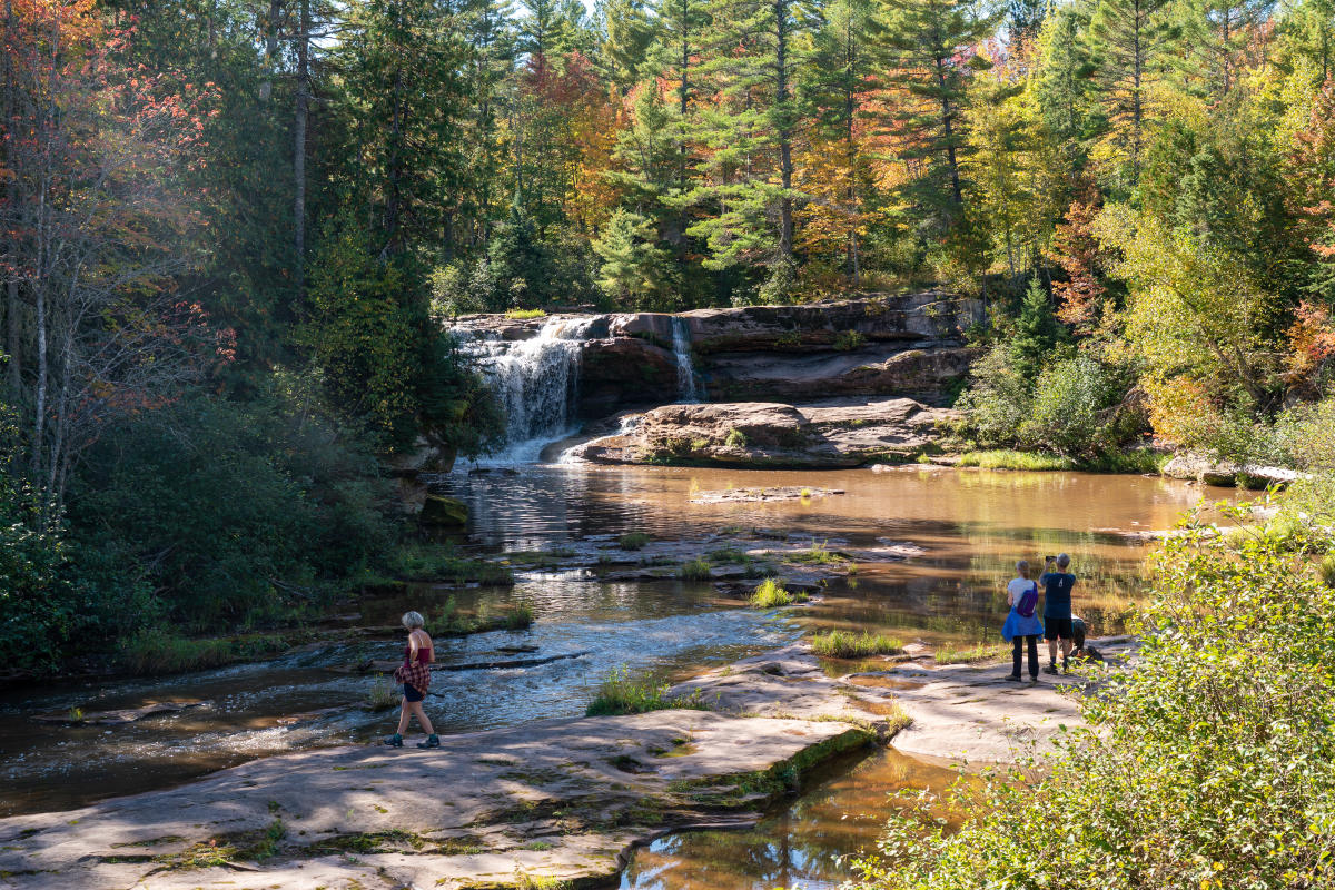
O Kun De Kun Falls includes a pleasant fall hike and beautiful views.
How to Get There
O Kun De Kun Falls isn’t really close to any community, which suits us because we know the crowds will be low and the chance to see wildlife high. From Houghton, start your journey by heading south on M-26 towards Ontonagon. Pass through the community of Mass City before jumping on US-45 south towards Bruce Crossing. After 6 miles you’ll see a brown hiking trail sign marking the parking area on the east side of the road (left side when heading south). Find online directions here.
There’s a small parking area big enough for about a dozen or so vehicles. There aren’t any bathrooms or potable water sources, so make sure you have those covered before heading out. In case they’re needed last second, the nearest bathrooms are at the Military Hills roadside park a few miles to the north. The trail to the falls begins right at the parking lot.
The Hike
The hike to O Kun De Kun Falls follows the North Country Trail (NCT), a 4,800+ mile route from North Dakota to Vermont. Fortunately, you don’t have to go that far to see the falls! Your hike is a 2.8 mile round-trip on a segment maintained by local volunteers from the Peter Wolfe Chapter of the NCT. Although much of the NCT through the Western U.P. can be quite challenging, the hike to O Kun De Kun Falls is much easier. The terrain is gentle with no big hills or chunky rocks, and for most of its length it is either a crushed gravel path or wide boardwalks. Perfect for kids!
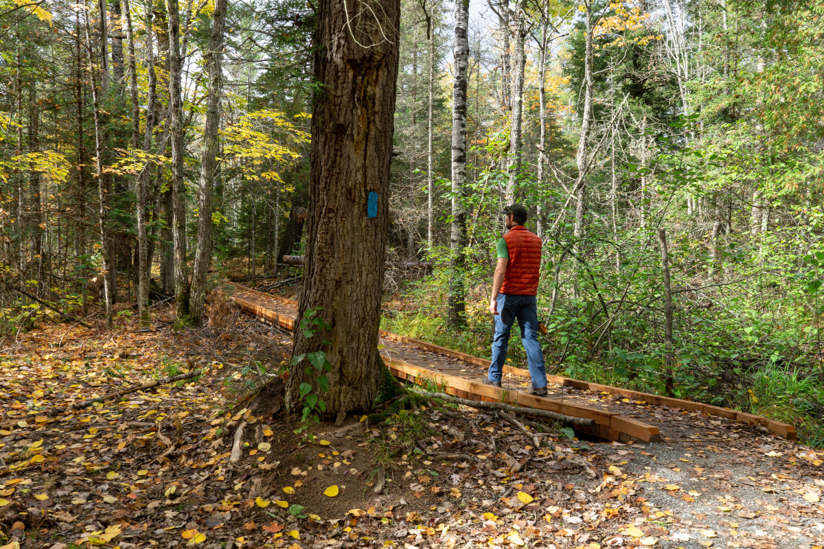
Be sure to follow the signs to the falls when you head out from the parking area. If you cross the road, you’re heading in the wrong direction. The first 1.1 miles of your hike is through a varied forest above the river. The trees are relatively young yet provide plenty of shade on sunny days - although the falling leaves will soon eliminate that advantage. Be careful on leaf-covered boardwalks in case they are slippery. Although the boardwalks are mostly flat, the leaves hold moisture and can cause you to slide unexpectedly.
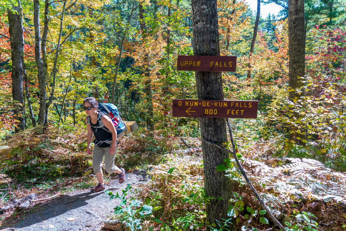
Follow the signs to find your way to the falls.
Navigation is fairly simple with very few options to get lost. You’ll cross just one old woods road along your journey. If you stay on the obvious path heading straight ahead, you’ll have no problems making it to your destination.
The Falls
There are actually two sets of waterfalls to visit near the end of your hike. The first, often called Peanut Butter Falls due to the brown color of the Baltimore River, drops 3-5 feet over a ragged edge of sandstone not far upstream from the main attraction. A more challenging footpath leads to the river for optimal viewing. It’s not quite the looker that the lower falls are but is still worth taking a peek at when you’re walking right past.
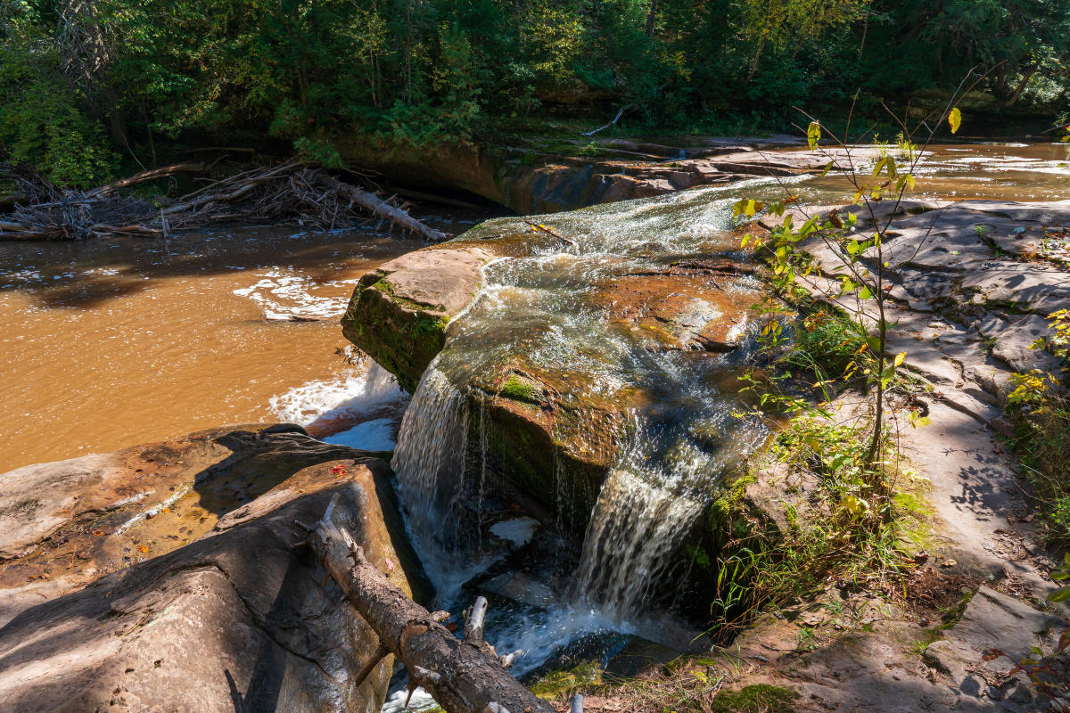
The upper falls are referred to as Peanut Butter Falls because of the brown color of the river.
Keep hiking downstream on the main footpath to reach O Kun De Kun Falls in about a quarter-mile. Just trust us when we say you’ll know you’re there! The trail opens up on a beautiful view out over the Baltimore River, with the main falls to your right and an impressive suspension bridge carrying the NCT over the river dead ahead. They don’t make wild scenes like this very often. Soak in the views and start exploring.
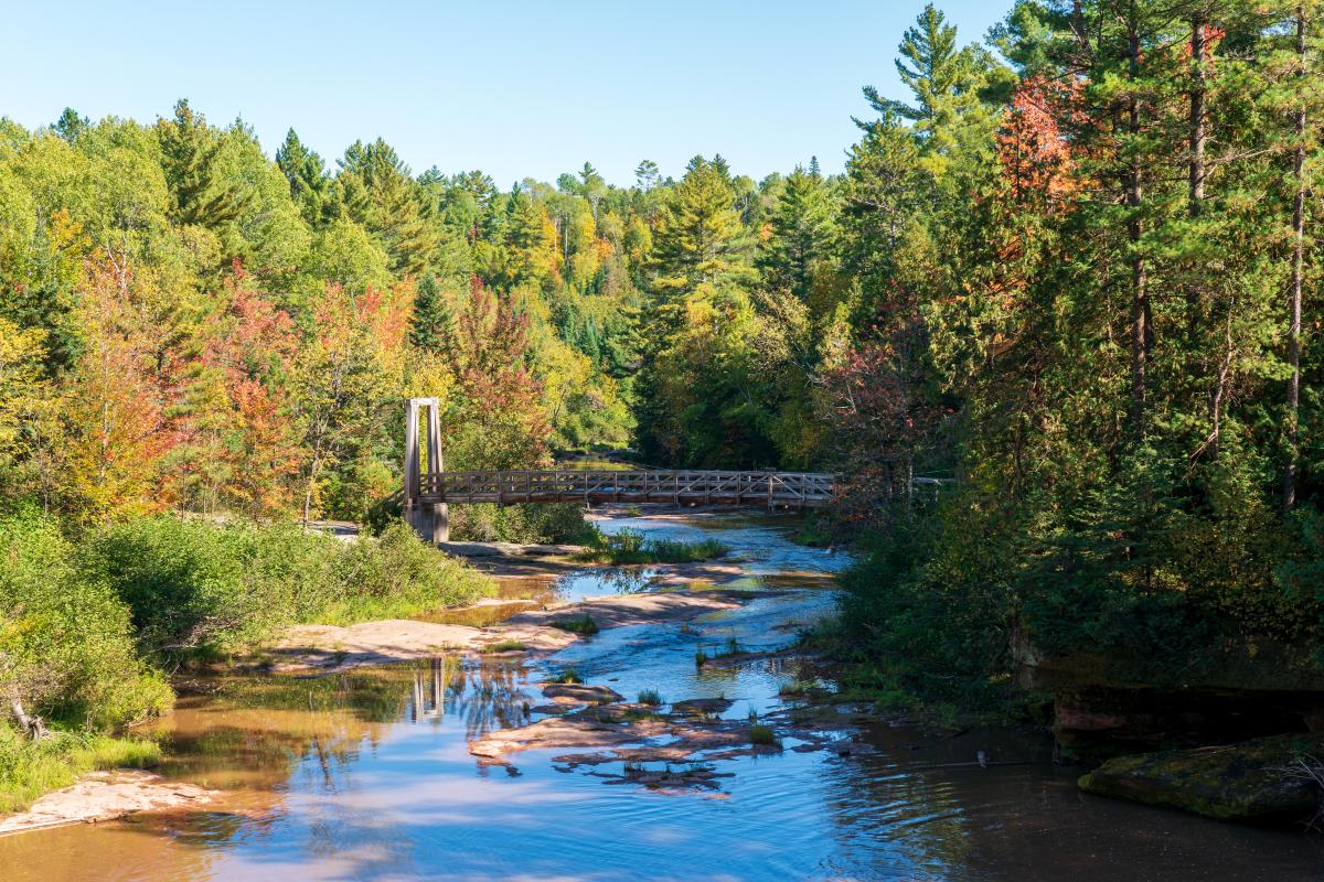
A suspension bridge spanning the Baltimore River makes it easy for hikers to cross.
If you’re adventurous and the water levels are low, the falls offer many different attractive angles for viewing. The sandstone ridge along the top offers many neat up-close looks as the river drops 20’+ into a big pool below. I’ve never heard of anyone swimming in the pool due to the potential for hidden dangers lurking in the murky waters, so save your dips for another day.
For the adventurous, it is possible to get a close up view of the falls. Be careful walking around slippery surfaces.
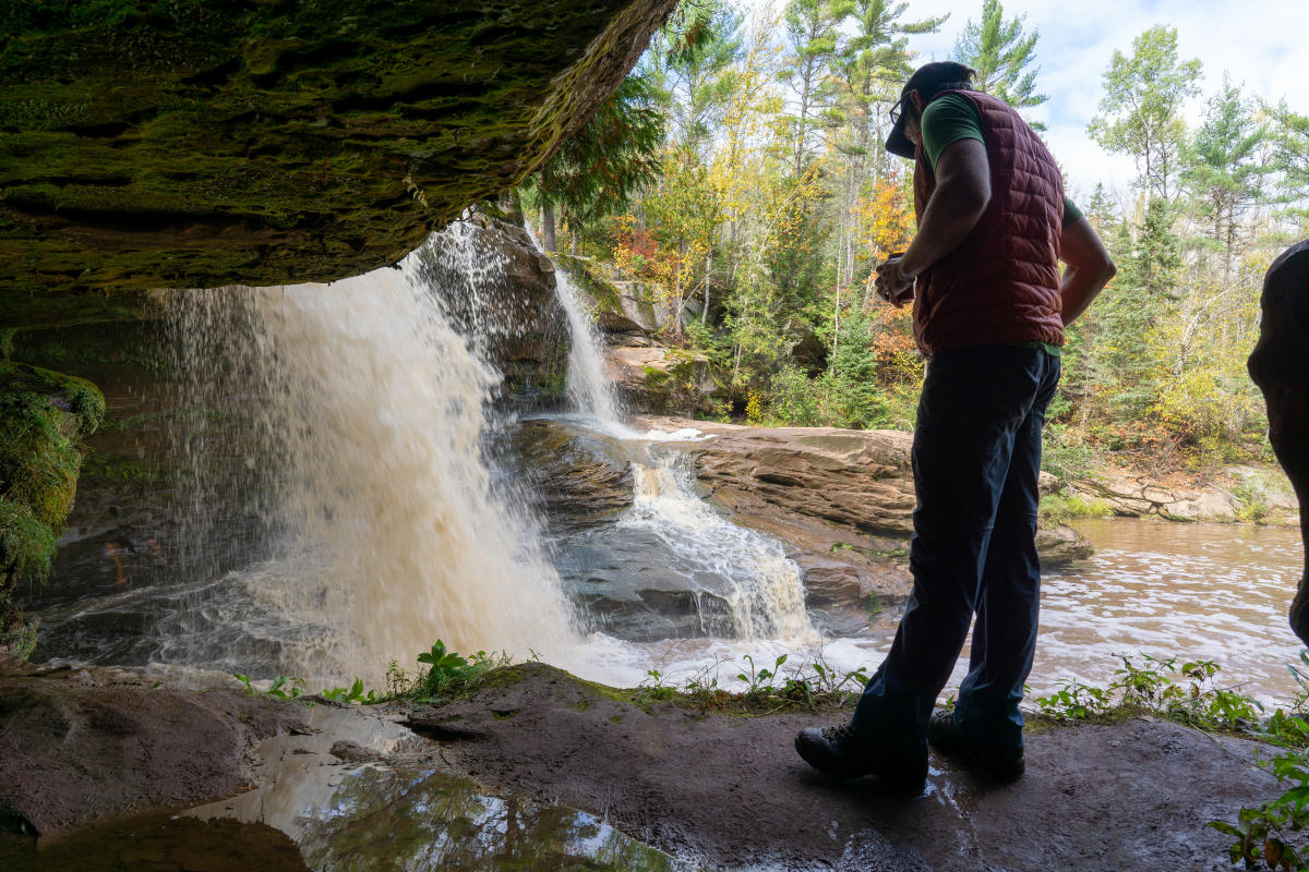
Possibly the coolest and most awe-inspiring viewing option is to sneak behind the falls themselves. Hike downstream on the NCT and cross the suspension bridge to the other side of the gorge. From there, hike upstream on the rugged footpath on the opposite bank as it snakes its way through fallen sandstone boulders. Soon you’ll find a cavern carved out of the relatively soft sandstone that leads behind the main drop. Watch out for slippery algae! Otherwise enjoy this unique experience with your friends and family.
To return to your vehicle, simply hike back uphill on the NCT the way you came in. The NCT continues beyond O Kun De Kun Falls on a seldom-traveled stretch towards another suspension bridge a few miles away over the Middle Branch Ontonagon River, but it is rough country and not usually recommended for day-trip sightseeing.
Things to Know
This area of the UP is far from anywhere. That means cell service may be sparse or non-existent. Although following the trail to and from the falls is simple, it never hurts to download maps ahead of time (both for the road and trail). Be sure to check the weather ahead of time and bring an extra layer in case it gets chilly on the hike back. The roughly 3-mile total journey can take 1.5-2 hours to complete or more depending on your pace and how long you spend at the falls.
Bring snacks and water for your trip if you plan to be out for a while. Always pack out your trash, and kindly grab any you see along the way to keep our trails clean. Leave what you find in the woods for others to enjoy. Definitely bring a camera to document those vibrant fall colors and waterfall scenes! If you see any wildlife along the way, be sure to give it plenty of clearance because these woods are their home. Finally, be courteous to other visitors. You likely won’t have the trail all to yourself on busy weekends, so don’t hog the best viewing spots or be rude to others. Check out our responsible recreation page for more tips.
Looking for more to do in this neck of the woods? Check out our guide to the Rockland and Victoria area for more waterfalls and historical treasures within striking distance of the Keweenaw!

Interested in updates, travel tips and quirky information about the Keweenaw? Just sign up for the Keweenaw Explorer, our monthly e-newsletter. Complete the form…